
Tsunamis:early warnings global networks.

What are the real possibilities for the development of a devastating tsunami in Peru? Certainly, this (s), go coupled to the frequency of earthquakes, that fracture or the seriously affect of the marine flats near our coasts. If we take into account the number of earthquakes, of greater or, smaller magnitude (8 in 2005), and to its main conditioner in the southern coast of Peru: slidings of the plate of Nasca, we will conclude that sufficient reasons exist to subscribe us to the world growing networks of early warning of tsunamis, sponsored by the UNESCO.
However not alone tsunamis are generated for fractures of the marine flats or by tectonic subduction (sliding of the plate of Nasca under the Continental plate), but also by sudden fallen of meteorites of medium size in lakes or seas, nuclear explosions, eruption or marine break of volcanic platforms. As it is known, the marine fractures, condition profound watery depressions that cause significant coastal marine backward movements (of to 1 km), the same that generate compensatory cumulative marine waves, that advancing to great pressure achieve heights of 10 - 150 meters, flooding coastal areas and causing great loss of life, by drowning.
-In 1960, an earthquake of magnitude: 9,5 with epicenter in central-south areas of Chile, generated tsunamis (with waves of 25 meters), throughout the coasts of the entire Ocean Pacific, killing about a thousand people. -The 16/10/1966, one tsunami struck 400 km of the Peruvian coasts, including the Callao harbour of Peru, where the waves reached heights of 3,4 mts. - In 1979, an earthquake of magnitude :7,9,con epicenter in Tumaco-Colombia generated a series of tsunamis in the coasts of Ecuador and Colombia, killing 350 people and wounding other 800. - The 21/2/1996, an earthquake of magnitude 6,9, with epicenter located 210 km south of Chimbote-Peru, generated a tsunami that killed 15 people. -The 12/11/1996, an earthquake of magnitude 6,4 with epicenter located 96 km south of Mancora-Peru, killed about twenty people
The 24/12/04, an earthquake of magnitude :9,1 generated a series of tsunamis, in the coasts of various countries looking to the Indic Ocean (Indonesia, Thailand, India, Sri Lanka, Tanzania, Kenya, Somalia, etc), killing 275 000 people a fact attributed to the lack in those countries of early preventive warnings coordinated network.
Thanks to Direction of Hidrografia and Navigation with headquarters in Callao, Peru is subscribed, since 1995, to the Preventive Tsunamis Warning Of Warning of Tsunamis (PTWC), pacific network, with headquarters in Hawaii. In this case, the deep marine sismic waves are grasped for marine buoys the same that with overall information coming from the superficial sea level are sent by means of: fax, e-mail, telex or, radio to Hawaii, from which are re-send to whom correspond. Although by the rapidity of its occurrence (Hokkaido. Japon. 12/07/93, when the tsunami ocurred 5 minutes after the earthquake or, Camana-Peru. 23/06/2001, when the the tsunami occurred 20 minutes after the earthquake of magnitude 8,1 in the scale of Richter (that killed 23 people and disappeared to other 63, which waves of 8,4 meters penetrated 1 km to the interior of firm land), some tsunamis are impossible of to be perceived.
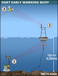
By fortune most tsunamis, give time for the taking of measures of safeguard: basically, fast evacuation of the population in danger. Besides it, it is possible a) to build walls of concrete, channels, floodgates, networks of trees (mangrove swamps, palm tree, etc), where possibilities of flood exist and b) the UNESCO, sponsors on a worldwide basis the creation of early alerts regional networks: connected to satellite systems (GLOSS and DART -faster and more effective that the PTWC-), the same that connected to marine sensors, detect increments fast and maintained of the presion of the deep sea. The information received by marine buoys, adds other originated in the marine sea level (elevations or, descents of level) and sends them to satellites, the same that re-send the data (alerting of the presence of tsunamis), to stations located in land.
Tsunamis : redes globales de alertas tempranas.
Que posibilidad existe para el desarrollo de un devastador tsunami en el Perú?. Por cierto, esta (s), van parejas a la frecuencia de terremotos, que fracturen o afecten seriamente los pisos marinos anexos a nuestras costas. Si nos atenemos al número de terremotos, de mayor o, menor intensidad : unos 8, el 2005 y a su principal condicionador en las areas costeras sureñas del Perú: deslizamientos de la placa de Nasca, concluiremos que existen suficientes razones para suscribirnos a las crecientes redes modernas mundiales de alerta temprana de tsunamis, patrocinadas por la UNESCO.
Pero los tsunamis no solo se generan por fracturas de los pisos marinos o por subducción tectónica (deslizamiento de la placa de Nasca por debajo de la placa Continental), sino también por caidas súbitas de meteoritos de mediano tamaño en lagos o mares o, explosiones nucleares, erupción o, rotura marina de plataformas volcánicas. Como se sabe, las fracturas marinas, condicionan depresiones acuosas que ocasionan significativos retrocesos marinos costeros (de hasta 1 km), los mismos que generan ondas marinas acumulativas compensatorias, que avanzando a gran presión logran alturas de 10 - 150 metros, inundando áreas costeras y ocasionando gran mortandad, por ahogamiento.
-En 1960, un terremoto de magnitud : 9,5 con epicentro en areas centro-sur de Chile, generó tsunamis (con olas de 25 metros), a lo largo y ancho de las costas del Océano Pacifico, matando a un millar de personas.
-El 16/10/1966,un tsunami golpeó 400 km http://www.callao.org/tsunami/ de las costas peruanas, incluyendo al Callao-Peru, donde las olas alcanzaron alturas de 3,4 mts.
- En 1979, un terremoto de magnitud :7,9,con epicentro en Tumaco-Colombia generó una serie de tsunamis en las costas de Ecuador y Colombia, matando 350 personas e hiriendo a otras 800.
- El 21/2/1996, un terremoto de magnitud 6,9, con epicentro ubicado 210 km al sur de Chimbote-Peru, generó un tsunami que mató 15 personas.
-El 12/11/1996, un terremoto de magnitud 6,4 con epicentro ubicado 96 km al sur de Mancora-Peru, mató una veintena de personas
- El 24/12/04, http://news.bbc.co.uk/1/hi/world/asia-pacific/4559404.stm un terremoto de magnitud :9,1 generó tsunamis en serie, en las costas de varios paises de cara al Océano Indico (Indonesia, Tailandia, India, Sri Lanka, Tanzania, Kenia, Somalia,etc), matando 275 000 personas, hecho atribuido a la carencia en esos paises de alertas preventivas tempranas
A traves de http://www.dhn.mil.pe/index.asp?pag=tsunami la Dirección de Hidrografia y Navegación con sede en el Callao, el Peru esta suscrito, desde 1995, al Preventive Tsunamis Warning Center-Centro de Alerta de Tsunamis (PTWC), con sede en Hawaii. En este caso las ondas sismicas marinas profundas, son captadas por boyas marinas las que de conjunto con información del nivel superficial de las aguas marinas, se envian mediante : fax, e-mail, telex o, radio a Hawaii, de donde se re-envian a donde corresponda.
Aunque por la rapidez de su ocurrencia (Hokkaido. Japon. 12/07/93, el tsunami ocurrio 5 minutos después de un terremoto, o: Camana-Peru. 23/06/2001, donde el tsunami ocurrio 20 minutos después del terremoto de magnitud 8,1 en la escala de Richter, que mató 23 personas y desapareció a otras 63 y , cuyas olas de 8,4 metros penetraron 1 km al interior de tierra firme), algunos tsunamis son imposibles de ser percibidos, por fortuna la mayoría de tsunamis, dan tiempo para la toma de medidas de salvaguarda: básicamente, evacuación rapida de la población en peligro. Además de ello, es posible a-construir murallas de concreto, canales, compuertas, redes de árboles http://news.bbc.co.uk/1/hi/sci/tech/4547032.stm (manglares, palmeras, etc), donde existan posibilidades de inundación y b) la UNESCO, patrocina a nivel mundial la creación de redes regionales de alertas tempranas http://news.bbc.co.uk/1/hi/sci/tech/4524642.stm conectadas a sistemas satelitales (GLOSS y DART -más veloces y efectivas que los PTWC-), los mismos que conectados a sensores marinos, detectan incrementos de subito y sostenidos de la presion del mar profundo. La información recibida por boyas marinas, agrega otras provenientes de la superficie marina (elevaciones o, descensos de nivel) y las envia a satelites, los mismos que reenvian los datos (alertando de la presencia de tsunamis), a estaciones ubicadas en tierra firme.
posted by Victor Mechán Mendez at 8:08 AM
![]()

.+Photo+Author.jpg)


0 Comments:
Post a Comment
<< Home